Arnside (in South Lakeland district, Cumbria) and Silverdale (in Lancaster district, Lancashire) is a quiet corner of the north-west, often overlooked by visitors focusing on the Lake District and Yorkshire Dales. Designated an Area of Outstanding Natural Beauty (AONB) in 1972, the area is mix of low hills, mosslands, woods, fields and small villages.
To the west is Morecambe Bay with its saltmarshes, mudflats and river channels, especially that of the River Kent. There is a big tidal range here and a bore on the Kent’s channel. The eastern boundary of the AONB is the A6 road.
From its offices and information centre (open weekdays) in the Old Station Building at Arnside the AONB’s staff of just four ensures the protection of the area from inappropriate development and encourages the public’s enjoyment of the natural and built environments.
The map later in this guide shows the dense network of well-signposted footpaths that allow walkers to explore the area. The limestone rocks provide a distinctive habitat for plants not often found elsewhere and the insects, butterflies and moths they host. In other places there are more acidic soils that extend further the botanical diversity of this area. Walkers may also see some of the deer that roam the low hills.
There is a rich bird life here. The RSPB’s reserve at Leighton Moss is very well known for its lakes and reedbeds surrounded by deciduous woodlands and fields. However, all the area’s woodland walks will display a good range of birdlife.
The western shore onto Morecambe Bay, at for example Jenny Brown’s Point, allows the bird watcher to get close to the shore birds of Morecambe Bay, particularly towards high tide and during the winter.
The maintenance of the built environment is also important, not only in the villages of Arnside, Silverdale, Beetham, Warton, Yealand Redmayne and Yealand Conyers but also in the farmhouses and cottages across the area. The stone walls need repairing and there is an active programme of volunteers who help out.
Evidence of the old tradition of coppicing trees can be seen widely. The AONB is actively running projects to keep rural skills alive, to encourage visitors and to improve both the natural environment and the historic landscapes.
By car the area is best accessed via the A6. By train the stations at Arnside, Silverdale and Carnforth are good points to start your walk or cycling.
These guides were written by Gordon Clark for the Lancaster Civic Society and are available to members of the Society.
Gordon has written over sixty fascinating walks, guides and leaflets across a whole range of aspects relating to the Lancaster and Morecambe district.
Membership of the Society includes, not only these guides and walks, but also monthly talks and lectures on topics that people from the Lancaster district, and those with an interest in the area, are finding extremely engaging, as well as a series of walking guides around the area in the summer months with local historian Peter Wade.
Our next walk with Peter Wade is on 11th August exploring Old Morecambe – Poulton le Sands
Interested in joining Lancaster Civic Society? Complete your details at our Contact & Join Uspage
The Forest of Bowland is a westerly extension of the Pennines, mostly in the districts of Lancaster, Ribble Valley and Craven, lying to the east of the M6. The hills are not high – Ward Stone at 1841ft (561m) is the highest – but the flat-topped moors and steep, wooded valleys are a distinctive and pleasant landscape for walkers.
The Forest of Bowland to the east of Lancaster (Google Earth)
Three of the area’s larger landowners are United Utilities (which uses the eastern part as the catchment for Stocks Reservoir); the Duchy of Lancaster (which owns the Whitewell Estate); and the Duchy of Westminster, at Abbeystead, a well-known sporting estate).
The landscapes of the area partly reflect its complex geology. This comprises hard rocks – a mix of limestones, shales, sandstones and millstone grits – which were laid down in two phases lasting around 40 million years during the Carboniferous era when the area enjoyed a more tropical climate.
Moors and wooded valleys – photo courtesy of Grosvenor Estates
A northward drift of continents and repeated tectonic upheavals have moulded the rocks into the hills and valleys we see today. The glaciations of the recent past have rounded off the hills and left glacial debris in the valleys’ bottoms and sides.
The landscape also reflects the history of its uses over the past centuries. The ‘Forest’ part of area’s name refers not to extensive woodland but to the royal hunting rights in the area that lasted till 1507, when smaller estates with farming, sport and country houses took over. The farming has long included sheep and cattle which have kept the trees at bay in the grazed areas uplands. The sport has focused on grouse shooting and from the air the tapestry of shorter and taller heather and the hill tracks to the shooting butts is unmistakable. By careful burning, the shorter, younger heather provides the grouse with food and the taller heather gives them shelter.
The heather patchwork of a Forest of Bowland Grouse Moor (Google Earth)
The scenic attractiveness of the area was officially recognised in 1964 when the Forest of Bowland was designated an Area of Outstanding Natural Beauty. A Joint Advisory Committee of local public and private interests guides the management of the area, strengthened by tighter planning laws to prevent unsuitable development.
The AONB actively promotes suitable types of development for the area’s 16,000 people. These focus on three themes – the wildlife, food and drink, and tourism.
The wealth of wildlife was one of the reasons for the area’s designation as an AONB and it has been recognised as a Special Protection Area under the European Birds Directive. The hen harrier is the iconic local species, which appears in the AONB’s logo. Nonetheless its breeding success rate is worryingly patchy.
The food-and-drink theme aims to raise the profile of local producers of, particularly, cheese and other dairy products, beer, beef, lamb and pork. Local restaurants feature them, and farmers’ markets and local shops and supermarkets make them readily available.
The tourism theme is diverse, to appeal to as many market segments as possible. Walking and cycling are promoted through leaflets and routes as is long-distance riding with the 45-km North Lancashire Bridleway from near Lancaster to Chipping.
The birdlife is a real attraction as are the villages and their eateries. The aim is to maximise the commercial benefits from visitors for local businesses. This prompted the area to bid for and be awarded a European Charter for Sustainable Tourism in Protected Areas.
Lapwing (left) Pendle Hill (right) – photos Forest of Bowland AONB
There is a Visitor Centre at Beacon Fell Country Park.
On the higher moorlands there is a general right of access for walkers only in the designated areas outlined in light yellow on the Ordnance Survey map OL41 (1:25,000, Forest of Bowland and Ribblesdale), which walkers should consult.
The Forest of Bowland can be accessed by train from the stations on the Lancaster to Skipton line and the line to Clitheroe – http://www.communityraillancashire.co.uk/
These guides were written by Gordon Clark for the Lancaster Civic Society and are available to members of the Society.
Gordon has written over sixty fascinating walks, guides and leaflets across a whole range of aspects relating to the Lancaster and Morecambe district.
Membership of the Society includes, not only these guides and walks, but also monthly talks and lectures on topics that people from the Lancaster district, and those with an interest in the area, are finding extremely engaging, as well as a series of walking guides around the area in the summer months with local historian Peter Wade.
Our next walk with Peter Wade is on 11th August exploring Old Morecambe – Poulton le Sands
Interested in joining Lancaster Civic Society? Complete your details at our Contact & Join Uspage
In Leaflet No. 65 in this series we showed Lancaster as it was portrayed in John Speed’s map of 1607 – basically a very small medieval town. By the time of Stephen Mackreth’s map published in 1778, the Town had grown considerably and the town centre is recognisably as it is today. His map is highly detailed, showing the outline of individual buildings as well as the streets. It is a large map – 60cm by 72cm.
A number of features stand out. There are the two images in the top-left-hand and top-right-hand corners showing the Castle and St Mary’s Church. Unusually, south is at the top of the map. It has a decorative border to make it resemble a framed picture on display in your house. It is an art work rather than a map to be used for navigation. It was a status symbol for the well off, costing 5 shillings (about £39 in today’s money) or you could buy seven for the price of six. The cartouche in the bottom-right-hand corner is interesting. It indicates the clientele who could afford the map.
The cartouche of Mackreth’s map. Note the ships and warehouses on the then recently developed St George’s Quay
So who was the cartographer, Stephen Mackreth? We know little of his life and this was his only map. At first sight he is an unlikely cartographer. Orphaned at four years of age, he was probably brought up by George Grey who was one of his father’s executors and a bookseller as Stephen’s father had been. Stephen was apprenticed at 14 to a joiner and cabinet maker. By the time he was 17 he was listed as a painter. Few cartographic skills there. However, George Grey was also a land surveyor – a useful skill for if you want produce a town map. The map is certainly the result of very accurate surveying. Grey’s son, Bryan, is probably the draughtsman for the map. The copper-plate engraving was advertised as being done in London. The printing could have been done by Mackreth because by the age of 36 in 1778 he is noted as being a printer too. George Grey moved in the right circles among Lancaster’s elite to drum up the subscriptions that would be needed to ensure that the map was a financially sound venture. Stephen Mackreth died in 1793 aged 51.
The Castle Hill areaThe Town Centre
The map is well worth close study, in terms of what has survived and what has not – the St Nicholas Street area and the Shambles, for example. What other changes can you spot?
These guides were written by Gordon Clark for the Lancaster Civic Society and are available to members of the Society.
Gordon has written over sixty fascinating walks, guides and leaflets across a whole range of aspects relating to the Lancaster and Morecambe district.
Membership of the Society includes, not only these guides and walks, but also monthly talks and lectures on topics that people from the Lancaster district, and those with an interest in the area, are finding extremely engaging, as well as a series of walking guides around the area in the summer months with local historian Peter Wade.
Interested in joining Lancaster Civic Society? Complete your details at our Contact & Join Uspage
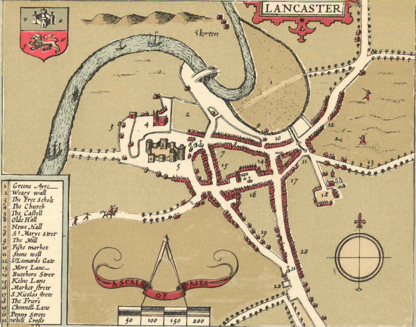
Lancaster is an old-established town – back to Roman times – but the first map that shows its layout in any detail did not appear until 1607 when John Speed surveyed the town. Here is his map.
John Speed’s project was to produce an atlas of each county, to be sold to the well-off. The map of Lancashire had an inset showing the streets and main buildings of Lancaster, the county town. It is one of 73 town plans in the atlas, which was first published in 1611/12. The full reference of the atlas is given at the end of this leaflet. An online version of the Lancaster town plan is available on the website of Lancaster University (see above).
Key to the numbers on John Speed’s map (1-22). it shows the names of the streets and main buildings
Speed had to get the permission from the Privy Council to carry out his surveys and he completed the Lancaster survey on 17 August 1607. He achieved a lot in one day but inevitably the map is rather sketchy. It was printed in black and white and then hand coloured before sale. The scale is 50 paces (250 feet) to the inch but is not consistent, particularly in the outskirts of the town.
The ‘Pinfolde’ was an area for penning animals. The Weary Wall was part of the Roman camp on Castle Hill.
Overall the town itself is fairly accurately portrayed, though the line of the River Lune is odd. The ordinary buildings of the town look formulaic rather than architecturally accurate. The key streets in the town centre are broadly aligned as we see them today.
There is St Marye Strete (now Church Street) running west-to-east down from the Castle and St Mary’s (The Priory) Church. To the south of this and roughly parallel is Market Strete and the Square.
The road from the south splits at the (literal) White Cross (noted on the map) as it does today, with Penny Strete and Butchers Strete (now Cheapside) running northwards and Chennell Lane (now King Street) going to the north-west. The map indicates a ‘Kelne Lane’ where China Street is now, and leading to the east are St Leonards Gate and More Lane (now Moor Lane).
The map also shows some major buildings. There is the Castell/Castle, as it was before the Civil War changed it. ‘The Church’ (St Mary’s Church) is shown with its tower – the medieval one not the current one which is Georgian. Towards the top of the map is the medieval bridge over the River Lune, which was finally demolished in 1846. Also shown on the map but no longer with us are the ‘Olde Hall’ and ‘Newe Hall’ and ‘The Friers’ (roughly where Dalton Square is today).
It is a fascinating map to study. If you would like to know more about this map you can consult these sources:
White A (2003) Lancaster: a History. Chichester: Phillmore. Chapter 4
Here is the full reference to Speed’s atlas:
Speed J 1611/12 The theatre of the empire of Great Britaine: presenting an exact geography ofthe kingdomes of England, Scotland, Ireland, and iles adioyning: with shires, hundreds, citiesand shire-townes, within ye kingdome of England, divided and described by John Speed. London: Sudbury & Humble
These guides were written by Gordon Clark for the Lancaster Civic Society and are available to members of the Society.
Gordon has written over sixty fascinating walks, guides and leaflets across a whole range of aspects relating to the Lancaster and Morecambe district.
Membership of the Society includes, not only these guides and walks, but also monthly talks and lectures on topics that people from the Lancaster district, and those with an interest in the area, are finding extremely engaging, as well as a series of walking guides around the area in the summer months with local historian Peter Wade.
Interested in joining Lancaster Civic Society? Complete your details at our Contact & Join Uspage
It is unusual to find two universities in a local authority district with a population of only around 140,000 and in a town with about 60,000 people. Lancaster is home to two universities, Lancaster University and what is now the Lancaster campus of the University of Cumbria. Both are well worth a visit for their varied and interesting architecture.
Lancaster University
Lancaster University’s campus at Bailrigg, just south of Lancaster, between the M6 (right) and West Coast Main Line railway and the A6 (left), looking north, Lancaster at the top.
A university in Lancaster was announced in 1961. In 1964 it received its Royal Charter and began operations in existing buildings in Lancaster itself. By 1970 most departments had moved to the new campus at Bailrigg, just south of the town. Today there are around 13,000 students in this medium-sized, highly-ranked university. The large campus covers 360 acres (146 ha).
The Bailrigg site in its modern form was established in 1899–1902 when H. L. Storey, one of Lancaster’s textile magnates, bought the estate and built Bailrigg House. It is in a neo-Elizabethan style and looking west it sits in gardens designed by Edward Milner and Thomas Mawson, the renowned Lancaster landscape architect. The shelter belts and planting scheme aided the hunting aspects of the estate.
The modern buildings are based around a compact design created by the architects, Bridgewater, Shepheard and Epstein in the early 1960s. There is a central square (‘Alexandra Square’) around which are clustered the shops, Library and administrative building.
North and south from the Square runs a covered, pedestrian walkway (‘The Spine’) alongside which are the colleges and teaching buildings. The earlier buildings were three-storeys, in brick, around quadrangles, in the Oxbridge college model. The Library followed this model too until its recent refurbishment.
Later buildings as the University expanded – including the very extensive recent replacement of 1960s student accommodation – have been taller and set apart from the original plan. The emphasis in the newer and expanded buildings has been on the flexibility of the future use of the internal spaces (as in the Library building) and the energy efficiency of the buildings in their construction and running (as in the LICA building).
There has been a major expansion of student accommodation to the south-west of the original site.
Chaplaincy Centre (left) InfoLab21 (right)
Perhaps the most architecturally notable of the buildings on the campus are the Chaplaincy Centre (1969), Ruskin Library (1998), InfoLab21 (2004) and the LICA building (2010).
Ruskin Library
A campus map (for satnav use LA1 4YW) can be downloaded from:
In Bowerham, just south of Lancaster city centre, lies the site now known as the Lancaster Campus of the University of Cumbria. Locally it is still known as “Saint Martin’s”.
From 1880 to 1959 the site was a barracks for the local King’s Own Royal Regiment. The Keep and Officers’ Mess survive as buildings, with new uses, as do some of the barracks themselves. When Lancaster College of Education was set up in 1964 – soon to be rechristened as St. Martin’s College – a major building programme took place to create the new facilities needed for teacher training.
The expansion of the College into other areas, such as the humanities and arts, nursing and health-related professions and business subjects, necessitated further new buildings around the site and new halls of residence. Originally overseen academically by the University of Manchester, it then came under the wing of Lancaster University, until the merger of local colleges in 2007 that created the University of Cumbria, which is based in Carlisle. The site is being redeveloped.
There are several buildings of interest for the visitor. The Harold Bridges Library (now extended) offers a striking facade and wonderful views west for its users. The Chapel, at the entrance to the College and its former parade ground, is the place of worship in this originally Church of England foundation.
Inside the Chapel, the crucifixion scene by John Bratby is thought provoking. The stone-built Keep reminds us of the military beginnings of the site. There are several works of art in the grounds around the buildings.
A campus map (for satnav use LA1 3JD) can be downloaded from:
These guides were written by Gordon Clark for the Lancaster Civic Society and are available to members of the Society.
Gordon has written over sixty fascinating walks, guides and leaflets across a whole range of aspects relating to the Lancaster and Morecambe district.
Membership of the Society includes, not only these guides and walks, but also monthly talks and lectures on topics that people from the Lancaster district, and those with an interest in the area, are finding extremely engaging, as well as a series of walking guides around the area in the summer months with local historian Peter Wade.
Our next ‘Walk and Talk’ scheduled with Peter Wade – subject to restrictions being lifted – is ‘Poulton le Sands – Old Morecambe’, followed by afternoon tea at the Aspect Bar, Lothersdale Hotel, Morecambe – with its magnificent views across the Bay – on 14th July 2:00 pm.
For a full list of events for the first half of this year visit our Events Calendar
Interested in joining Lancaster Civic Society? Complete your details at our Contact & Join Uspage
Roger Frankland has for over twenty years conducted monthly guided tours around the Lancaster Cemetery.
Roger has conducted these tours on behalf of Lancaster Civic Society, free of charge, once a month on the third Sunday commencing at 2:00 pm meeting at the gates.
Through these tours hundreds of people have been able to appreciate the wonderful heritage in Lancaster Cemetery over these years.
Memorial to James Williamson, Baron Ashton
Whilst the tours have of necessity been suspended during the pandemic it was anticipated to restart them again this month however, following the Prime Minister’s announcement on Monday evening, it has been decided that, in the interests of everyone’s safety, restarting them at this time would be premature.
Accordingly the proposed tour on 20th June, and all subsequent ones following, will not now take place until such time as circumstances allow for them to be conducted safely for everyone involved.
As soon as they do restart they will be added to our ‘Events’ page as well as being announced through our Blog & News page.
If you would like to learn more about Lancaster Cemetery and its heritage Gordon Clark has written three leaflets for the Civic Society – no. 2 Crosses in Lancaster Cemetery, no. 3 Lancaster Cemetery and no. 63 Lancaster Cemetery: Notable Gravestones and Memorials.
The Skew Bridge over the A6 at Galgate and the viaduct over the River Conder were designed by Edmund Sharpe, the noted Lancaster architect.
Galgate – from Google Earth – M6 on the right, West Coast railway line in the centre, A6 crossing under the railway, Lancaster Canal and Marina on the left
John Ogilby’s road map of 1675 showing ‘Gaugut’ bridge
Galgate is a village south of Lancaster on the A6, sadly known today as a bottleneck where north-south traffic is squeezed through the village’s narrow main street and across an east-west road. This junction is seen in the centre of the satellite photograph above and in Ogilby’s road map of 1675.
The medieval road north went along the higher, drier ground (now Highland Brow and Burrow Road). This was superseded in 1824 by the Garstang and Heiring Syke (turnpike) Trust’s straighter and more level road (the current A6) that passes Lancaster University.
The north–south theme was continued when the Lancaster to Preston canal opened in 1797. The Lancaster and Preston Junction railway (now the West Coast Main Line) opened in 1840 (there was a Galgate station till 1939). The Skew Bridge over the A6 at Galgate and the viaduct over the River Conder were designed by Edmund Sharpe, the noted Lancaster architect. The M6 (the UK’s third stretch of motorway) opened in 1960. The road east from Galgate goes to Dolphinholme and to the west to Glasson. A canal branch linked Galgate and Glasson after 1826.
The expansion of Galgate, beyond a place that serviced travellers and the local farming community, came with the development of textile mills, as happened in many of the villages around Lancaster.
The three Galgate mills specialised mostly in silk, especially the spinning of waste silk, though flax, cotton and nylon were also produced at times. The first mill, on the west side of Chapel Lane, was a corn mill until it switched to silk production in 1792 in a two-storey building and expanded in 1832 into a three-storey building. The boiler house and square chimney are still visible. Water-powered by the River Conder it was reputedly the first mechanical silk-spinning mill in the UK and was run, like the others in Galgate and some in other villages, by combinations of two generations of local Armstrongs, Nobles and Thompsons.
The first silk mill (OS survey 1844-5, courtesy Lancashire CC)Central Galgate (the second silk mill, River Conder and railway (OS survey 1844-5)
The second mill was on Salford Road, west of the crossroads, and again used the Conder for water power. Called Low Mill, it was operating by 1801, first for flax and cotton and then for silk by 1836 and for a short time in the 1860s for cotton again. The original three-storey mill was expanded into a four-storey extension. The mill was partly demolished in 1895 but remnants are visible.
The third and largest of the mills was built in 1851–2 on the east side of Chapel Lane, opposite the first mill. John Armstrong may have designed it for his company, which traded as William Thompson and Co. It is an imposing five-storey structure in red brick with a water tank in the north-west corner of the roof. The engine shed, chimney and the remains of the mill pond and water race from the Conder are all still visible as is Ellel House, the early-19th-century manager’s house near the mill, now part of a nursing home.
Coal for the mills arrived via the canal branch from Glasson Dock and the mill supplied gas for Galgate’s street lighting. Terraced housing on the east side of Main Road was provided by the mill. The Thompson mill closed in 1971, England’s last silk spinner, with the loss of 85 jobs – over 400 had been employed in these mills at times during the previous century. The building has recently been converted into student accommodation.
The first and third Galgate silk mills
There are two notable houses around Galgate. The grandest is Ellel Grange just south of the village. Built in 1857–9 for William Preston (a Liverpool merchant and Mayor), the style is almost exotically Italianate, with two towers resembling those at Queen Victoria’s Osborne House. The interior is imposing, and the furnishings were largely by Gillow of Lancaster.
There are 12 acres (5 ha) of parkland with impressive trees, the Preston family mausoleum and a chapel. Ownership passed to the Sandeman family (of port fame) and then to the current owners, Ellel Ministries, an international, non-denominational Christian healing organisation.
Just west of Galgate is Ellel Hall, the seat of the Ford family. The current house dates from the early nineteenth century; there is fine stonework with three bays and an impressive pediment over the front door. The house was bought by Lord Ashton, Lancaster’s linoleum magnate, in 1898 and refurbished soon after. It is currently a private house.
Galgate has three churches within a few hundred metres of each other. St Joseph’s RC is on Main Road, converted from an infant school around 1970. The Wesleyan Methodist chapel (a late-nineteenth century building) is round the corner on Chapel Lane where you can also find St John the Evangelist (Church of England), which was built in 1906–7 to a design by Paley and Austin, the noted Lancaster architects. The stained glass is by Shrigley and Hunt of Lancaster.
A recent development is the new Ellel Village Hall to the south of the village (see below). Sited near the playing fields and the allotments, the hall is a busy centre for many local community activities. Galgate also has a large primary school and a pub and shops, and a marina on the canal. Several groups of new houses have been added to the village in recent years. There are plans for a new M6 junction to remove much of the village’s through traffic.
These guides were written by Gordon Clark for the Lancaster Civic Society and are available to members of the Society.
Gordon has written over sixty fascinating walks, guides and leaflets across a whole range of aspects relating to the Lancaster and Morecambe district.
Membership of the Society includes, not only these guides and walks, but also monthly talks and lectures on topics that people from the Lancaster district, and those with an interest in the area, are finding extremely engaging, as well as a series of walking guides around the area in the summer months with local historian Peter Wade.
Our next ‘Walk and Talk’ scheduled with Peter Wade – subject to restrictions being lifted – is ‘Poulton le Sands – Old Morecambe’, followed by afternoon tea at the Aspect Bar, Lothersdale Hotel, Morecambe – with its magnificent views across the Bay – on 14th July 2:00 pm.
For a full list of events for the first half of this year visit our Events Calendar
Interested in joining Lancaster Civic Society? Complete your details at our Contact & Join Uspage
The Clock Tower on Morecambe’s Marine Road Central is one of the town’s smaller but more distinctive landmarks.
Lancaster Civic Society Leaflet 67
It symbolises the late-Victorian and Edwardian expansion of the town in terms of population and facilities, adding to its growing reputation as a major seaside resort. The Tower was installed on the seafront next to the Central Pier and around half a mile from the Winter Gardens and Harbour.
‘Promenading’ was a common pastime for visitors who might need to know the time – meal times at their boarding house or the times of shows – but not have a watch. As the photographs at the end of this leaflet show, this was a bustling part of Morecambe. Usefully, public toilets were right next to the Clock Tower (underground and with a landscaped roof area). They have been rebuilt at ground level.
The Tower’s story starts with the generosity of Alderman and then Mayor John Robert Birkett JP who had pledged £400 of his own money (nearly £50,000 in 2020 value) to part-fund a public library for Morecambe. This plan fell through when the Council refused to raise the rates to pay for its upkeep. Birkett then switched his donation to the construction of a Clock Tower. He made his proposal formally to the Council in March 1905 with the aim of ‘opening’ the Clock Tower on 22 July.
The Tower was designed by Cressey and Keighley, a short-lived architectural practice on Euston Road, Morecambe. It was built by Messrs Edmundson. The clock was made by Rhodes of Lancaster and there is an internal vertical ladder within the Tower to give access to the clock mechanism.
There is a memorial and foundation stone laid by the Mayor’s wife on 24 June 1905. After very rapid construction, the Tower was declared ready on 6 September 1905 and the clock was illuminated for the first time two days later. Oddly there was no formal opening or unveiling ceremony.
There was an objection to the Tower’s location from a neighbour who said it would damage his view but this was overruled. One councillor did not approve of so much building on the seaward side of the Promenade. An alderman thanked the Mayor for his generosity but recalled the criticisms made while it was being built. The month after it was opened, there was a debate in the Council about whether they could afford to illuminate the four clock faces. The Mayor’s generosity did not extend to its running costs.
In practice the Mayor’s £400 did not buy the town all that much Tower. It is only 46 feet tall (14 metres). It is built in a striking design of red brick with buff sandstone banding and dressing. There used to be benches around the base between the four corner buttresses, each with a roof to give sheltered seating, but these have been lost.
The Tower was partly functional – to give the time to those without watches – and partly to decorate the Promenade. The Central Pier next door and much else of Morecambe in its heyday have disappeared. The Clock Tower remains. Here are some photographs of the Clock Tower area in busy times, taken from Lancashire County Council’s Red Rose Collection, which we gratefully acknowledge. The first two are Edwardian, taken soon after the Tower had been built.
These guides were written by Gordon Clark for the Lancaster Civic Society and are available to members of the Society.
Gordon has written over sixty fascinating walks, guides and leaflets across a whole range of aspects relating to the Lancaster and Morecambe district.
Membership of the Society includes, not only these guides and walks, but also monthly talks and lectures on topics that people from the Lancaster district, and those with an interest in the area, are finding extremely engaging, as well as a series of walking guides around the area in the summer months with local historian Peter Wade.
Our next ‘Walk and Talk’ scheduled with Peter Wade – subject to restrictions being lifted – is ‘Poulton le Sands – Old Morecambe’, followed by afternoon tea at the Aspect Bar, Lothersdale Hotel, Morecambe – with its magnificent views across the Bay – on 14th July 2:00 pm.
For a full list of events for the first half of this year visit our Events Calendar
Interested in joining Lancaster Civic Society? Complete your details at our Contact & Join Uspage
One road yet two names at either end – but what is it’s real name?
St Leonard Gate, St Leonard’s Gate, St Leonard Street, St Leonardgate, St Leonardsgate and St Leonard-gate have all been used. If the Local Authority doesn’t know you can choose!
Lancaster Civic Society Leaflet 64
You know where you are in a town by the street names that comprise the addresses of houses and other buildings. We think of street names as fixed, for convenience if nothing else. But Lancaster has witnessed a number of cases where the name of a street still found today was changed at some point in the past.
This leaflet does not deal with streets given a name that remains in use today, nor with streets that no longer exist. Nor does it consider minor changes of spelling – for example, More Lane and Mo0r Lane; Dam Side (or Dam Side Street) t0 Damside Street.
Here are some examples of name changes in Lancaster streets. This is largely based on the series of early maps of Lancaster before the first Ordnance Survey maps in the 1840s and then the subsequent OS maps.
The earliest map was compiled by John Speed in 1607. Then came Richard Kuerden’s map of 1685 (sometimes called the Towneley or Docton map). Stephen Mackreth’s map of 1778 was followed by Christopher Clark’s map of 1807, Jonathan Binns’s map of 1821 and Edward Baines’s map of 1824.
Harrison and Hall’s map of Lancaster in 1877 fills a gap in the OS coverage. The streets of Morecambe and Heysham were mostly created more recently than those in central Lancaster and so changes of name are far rarer there.
Sometimes it is not clear whether a name applies only to a group of houses or whether for a time that name also applied to the street and so formed a postal address now no longer in use. Further research will be needed to date exactly and explain some of the name changes.
Aldcliffe Road
One of the simple changes was when Aldcliffe Road was ’promoted’ from a Lane to a Road between the OS 6-inch map of 1844 and their 1891 map.
Ashford Road
This was a lane westwards from the Scotforth crossroads, unnamed on the 1891 OS 6-inch map, but by the 1910 map it was called Ashford Road. Meanwhile a group of ten houses along its eastern end had been named Portland Terrace, a name no longer in postal use, but still visible to passers-by.
Barton Road
As late as the OS 6-inch map of 1910, this was called Barton Lane. The road was realigned in the late 1920s and by the 1931 OS 6-inch map it had been ‘upgraded’ to Barton Road.
Bowerham Road
A group of houses on Bowerham Road, built in 1895–6 near its present-day junction with Coulston Road, was originally known as Gordon Terrace or Gordon Villas. As building extended south from Adelphi Street after the 1891 OS map, the name Bowerham Road came to cover these properties in normal usage though Gordon Terrace is still their correct postal address. Bowerham Road was still Bowerham Lane on Harrison and Hall’s map of 1877 and a northern part of it was called Bowerham Terrace. The southern section of Bowerham Road continued to be called Bowerham Lane until housing was built along it and it too became Bowerham Road.
Bulk Road
What is now Bulk Road was, until the First World War, Germany Street. On Mackreth’s map of 1778 there was no Germany Street, just Germany Bridge which spanned the ‘Old Mill Race’ to Damside Street or Dam Side.
Caulkeld Lane
This is the short, steep passage between Church Street and Damside Street. It was called Caucalt Lane on Kuerden’s map of 1675 and Calcold Lane on Mackreth’s map of 1778. This is more a respelling of how this very minor road’s name was pronounced than a full renaming. It is one of Lancaster’s oldest streets.
Charles Street
This short street in Greaves was called Alfred Street until the 1880s.
Cheapside
Cheapside continues the line of Penny Street between Market Street and Church Street. It used to be called Pudding Lane and before that Butcher Lane /Street. On Baines’s map of 1824 Pudding Lane had become Cheapside.
China Street
In 1899 it became China Street rather than China Lane after the road had been widened. Speed’s map called it Kelne Lane and Kuerden’s map used Chiney Lane.
Church Street
Speed’s map referred to St Mary Strete. Later, Kuerden’s map called it St Mary or Church Street. By Mackreth’s map of 1778 it was firmly Church Street. ‘St Mary’ is the official name and dedication of what is often called the Priory Church on Castle Hill.
Greaves Road
Three groups of terraced houses (Halcyon Terrace, c. 1856; West Greaves c. 1857; and Vine-Yards built by 1871) are today part of Greaves Road but predate the naming of that street.
Hala Road
Up to the OS 25-inch map of 1889 the road east from the Scotforth crossroads was called Hala Hill. The western section in Scotforth Village had become Hala Road by the time of the OS25-inch map of 1910. The road eastwards from the ford over the beck remained Hala Hill and that is still its name though it has been realigned.
King Street
The road that runs from White Cross north to its junction with China Street and Market Street is today called King Street. Previously there were many name changes.
On Speed’s map of 1607 it is called Chennel Lane. Kuerden’s map of 1685 uses Kemps Lane for the northern section between roughly Spring Garden Street and the Market Street junction, and uses Back Lane for the southern section from Spring Garden Street to White Cross. Mackreth’s map of 1778 calls the whole route Back Lane.
Baines’s map of 1824 renames the northern section (between Market Street and Common Garden Street or Middle Street) King Street, while the southern section remains as Back Lane. Harrison and Hall’s map of 1877 names the southern section Upper King Street. The whole street – Market Street to White Cross – had become King Street by the time of the OS 6-inch map of 1891.
Long Marsh Lane
On Mackreth and Clark’s maps of 1778 and 1807 Marsh Lane ran west from Castle Park, forking into, first, the route that now runs westwards over the railway line and, second, another branch to the north west, also called Marsh Lane. These had become West Road and Long Marsh Lane respectively by the time of the OS 6-inch map of 1844. Part of Long Marsh Lane comprised cottages formerly known as Wennington Place.
Lune Street
On all the early maps this road in Skerton was simply ‘the road to/from Kendal’ leading north from the medieval bridge over the River Lune, near today’s Millennium Bridge. Baines’s map of 1824 showed it as Cross Street as did the OS 6-inch map of 1844. By the OS map in 1891 it had become Lune Street.
Meeting House Lane
Kuerden’s map of 1685 calls this track out of the town ‘Kiln Lane’. By the time of Mackreth’s map in 1778 it is has been renamed Meeting House Lane, the Friends Meeting House having been built there in 1677 and rebuilt in 1708.
Morecambe Road
As late as the 1910 OS 6-inch and 25-inch maps this road west from Skerton Bridge was called Heysham Road – it went via Oxcliffe. The main road to Morecambe was then further north via Torrisholme.
When today’s direct road to Morecambe was opened in 1922, the whole route west from Skerton was named Morecambe Road and this is how it was shown on the OS 6-inch map of 1931.
New Street
Laid out around 1745, this street was called ‘Charles or New Street’ on Mackreth’s map of 1778 but by Clark’s map of 1807 it had settled on New Street.
North Road
Between 1877 and 1890 what is now North Road was renamed, having previously been part of Damside Street.
Park Road
Called Quarry Road sometime before 1877.
Queen Street
By Clark’s map of 1807 this had become Queen Street but on Mackreth’s map of 1778 the road leading off Queen Square is called Rope Walk and is shown as a country lane rather than a town road. The renaming coincides with the building of new properties along the street.
St Leonard’s Gate
This is perhaps the most contentious street name in Lancaster in terms of its spelling, though the essence of its name has not changed. Kuerden called it St Leonard Street. Today the Ordnance Survey and Open Street Map use St Leonard’s Gate.
The Royal Mail calls it St Leonards Gate. Early town maps by Mackreth and Clark prefer St Leonard Gate. The street name-plates at the east and west ends of the street use different spellings. In many older publications St Leonardsgate, St Leonardgate and St Leonard-gate were used. Take your pick!
One street with a different sign at each end
Scotforth Road
Two groups of terraced houses built along what is now Scotforth Road were called Rose Bank (1889) and Sea View (1893). These names disappeared from postal use when Scotforth Road was designated. The OS 6-inch map of 1910 is the first to show Scotforth Road by that name, Lancaster’s borough boundary having been moved southwards. The earlier designation of Scotforth Road was as a part of the Garstang and Heron Syke Turnpike Road.
Spring Garden Street
Sometime before Mackreth’s map of 1778, Spring Garden Street was called Mackrell Street, with various spellings of Mackrell. The name may derive from a local innkeeper and landowner.
Other useful sources of information include:
1) Andrew White and Michael Winstanley’s book on Victorian Terraced Housing in Lancaster. (Lancaster: Lancaster University: Centre for North-West Regional Studies, 1996).
2) Andrew White’s book on Lancaster: a History. (Chichester: Phillimore).
If you know of other local streets that have changed their names, do let us know.
These guides were written by Gordon Clark for the Lancaster Civic Society and are available to members of the Society.
Gordon has written over sixty fascinating walks, guides and leaflets across a whole range of aspects relating to the Lancaster and Morecambe district.
Membership of the Society includes, not only these guides and walks, but also monthly talks and lectures on topics that people from the Lancaster district, and those with an interest in the area, are finding extremely engaging, as well as a series of walking guides around the area in the summer months with local historian Peter Wade.
Our next ‘Walk and Talk’ scheduled with Peter Wade – subject to restrictions being lifted – is ‘Poulton le Sands – Old Morecambe’, followed by afternoon tea at the Aspect Bar, Lothersdale Hotel, Morecambe – with its magnificent views across the Bay – on 14th July 2:00 pm.
For a full list of events for the first half of this year visit our Events Calendar
Interested in joining Lancaster Civic Society? Complete your details at our Contact & Join Uspage
Fairfield is an area to the south-west of central Lancaster. It is a mix of late nineteenth-century and interwar housing.
Lancaster Civic Society leaflet 36
Our focus here is on the open space to the south of that; the large green area between the housing, shown below.
The Fairfield area between Lancaster Canal and Haverbreaks (bottom right) and Abraham Heights (top left)
Land so close to the city could be developed for housing: therefore, to protect it, the Fairfield Association was set up in 1996. They manage the long-established Fairfield Allotments (4.4 acres) on behalf of the Lancaster City Council.
Their first target was to buy nearby derelict garages (proposed for housing), demolish them and use the land to extend the City Council’s long-established Fairfield Green play area. A range of new play equipment was installed.
The allotments, play area (top) and orchards (bottom)
The allotments, Williamson Memorial on the horizon
Play area, Castle and Priory on the horizon
The next task was to convert nearby unused land into a Millennium Orchard (2.2 acres, 1999). This has a wide variety of fruit and nut trees and anyone can pick the produce of this community orchard. The Association leases the site from the City Council.
The Orchard in spring
Moving further out they leased 16 acres in 2011–2 from the City Council to form Fauna, an actively managed Local Nature Reserve. New footpaths give public access to the whole area and new ponds and hedges have been created.
There are many habitats here, including pasture, wet pasture and boggy areas. The old hedges and a variety of mature trees offer a diversity of niches for many species of plants, birds and animals. A wild flower meadow is developing. The area is grazed by White Park cattle, a rare heritage breed.
FAUNA sculpture
White Park cattle
The next stage was the Flora project. This saw the Association raise around £300,000 to buy 34 acres from various owners to form a major extension to the nature reserve.
This completes the green wedge between Lancaster Canal and the existing housing in south-west Lancaster, ensuring that the whole area will be a green community asset in perpetuity for walkers, nature lovers and the local residents.
Remarkable features of the Fairfield Association’s work have included the twenty years of hard effort needed to achieve what they have, and their ingenuity and skill in fundraising to turn their ideas into over 56 acres (c.23 ha) of valuable and useful assets, protected in perpetuity for us all.
The Association has recently taken over a small triangular plot beside Lancaster Canal on Aldcliffe Road for future community use. The Fairfield lands can be accessed most easily from either Cromwell Road (off Aldcliffe Road) or Ashfield Avenue and Sunnyside Lane (off Westbourne Road).
Wildlife pond – Castle on the horizon
Text and ground photographs – Gordon Clark. Satellite imagery – Google Earth.
These guides were written by Gordon Clark for the Lancaster Civic Society and are available to members of the Society.
Gordon has written over sixty fascinating walks, guides and leaflets across a whole range of aspects relating to the Lancaster and Morecambe district.
Membership of the Society includes, not only these guides and walks, but also monthly talks and lectures on topics that people from the Lancaster district, and those with an interest in the area, are finding extremely engaging, as well as a series of walking guides around the area in the summer months with local historian Peter Wade.
Our next ‘Walk and Talk’ scheduled with Peter Wade – subject to restrictions being lifted – is ‘Poulton le Sands – Old Morecambe’, followed by afternoon tea at the Aspect Bar, Lothersdale Hotel, Morecambe – with its magnificent views across the Bay – on 14th July 2:00 pm.
For a full list of events for the first half of this year visit our Events Calendar
Interested in joining Lancaster Civic Society? Complete your details at our Contact & Join Uspage