


Lancaster Civic Society Leaflet No. 65
Lancaster is an old-established town – back to Roman times – but the first map that shows its layout in any detail did not appear until 1607 when John Speed surveyed the town. Here is his map.

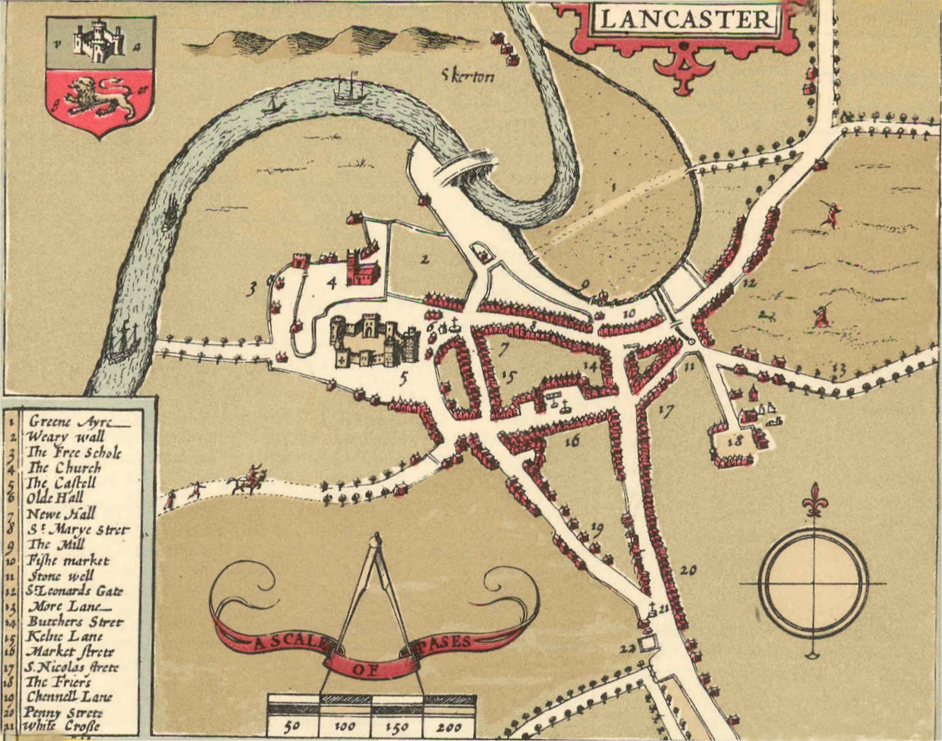
John Speed’s project was to produce an atlas of each county, to be sold to the well-off. The map of Lancashire had an inset showing the streets and main buildings of Lancaster, the county town. It is one of 73 town plans in the atlas, which was first published in 1611/12. The full reference of the atlas is given at the end of this leaflet. An online version of the Lancaster town plan is available on the website of Lancaster University (see above).

Speed had to get the permission from the Privy Council to carry out his surveys and he completed the Lancaster survey on 17 August 1607. He achieved a lot in one day but inevitably the map is rather sketchy. It was printed in black and white and then hand coloured before sale. The scale is 50 paces (250 feet) to the inch but is not consistent, particularly in the outskirts of the town.
The ‘Pinfolde’ was an area for penning animals. The Weary Wall was part of the Roman camp on Castle Hill.
Overall the town itself is fairly accurately portrayed, though the line of the River Lune is odd. The ordinary buildings of the town look formulaic rather than architecturally accurate. The key streets in the town centre are broadly aligned as we see them today.
There is St Marye Strete (now Church Street) running west-to-east down from the Castle and St Mary’s (The Priory) Church. To the south of this and roughly parallel is Market Strete and the Square.
The road from the south splits at the (literal) White Cross (noted on the map) as it does today, with Penny Strete and Butchers Strete (now Cheapside) running northwards and Chennell Lane (now King Street) going to the north-west. The map indicates a ‘Kelne Lane’ where China Street is now, and leading to the east are St Leonards Gate and More Lane (now Moor Lane).
The map also shows some major buildings. There is the Castell/Castle, as it was before the Civil War changed it. ‘The Church’ (St Mary’s Church) is shown with its tower – the medieval one not the current one which is Georgian. Towards the top of the map is the medieval bridge over the River Lune, which was finally demolished in 1846. Also shown on the map but no longer with us are the ‘Olde Hall’ and ‘Newe Hall’ and ‘The Friers’ (roughly where Dalton Square is today).
It is a fascinating map to study. If you would like to know more about this map you can consult these sources:
Webster D N (2020) John Speed’s Town Plan of Lancaster in 1607. Contrebis 38, 23–8. Available at https://lahs.archaeologyuk.org/contrebis38.htm
White A (2003) Lancaster: a History. Chichester: Phillmore. Chapter 4
Here is the full reference to Speed’s atlas:
Speed J 1611/12 The theatre of the empire of Great Britaine: presenting an exact geography of the kingdomes of England, Scotland, Ireland, and iles adioyning: with shires, hundreds, cities and shire-townes, within ye kingdome of England, divided and described by John Speed. London: Sudbury & Humble
Text – Gordon Clark. Published by Lancaster Civic Society (©2021). www.lancastercivicsociety.uk
These guides were written by Gordon Clark for the Lancaster Civic Society and are available to members of the Society.
Gordon has written over sixty fascinating walks, guides and leaflets across a whole range of aspects relating to the Lancaster and Morecambe district.
Membership of the Society includes, not only these guides and walks, but also monthly talks and lectures on topics that people from the Lancaster district, and those with an interest in the area, are finding extremely engaging, as well as a series of walking guides around the area in the summer months with local historian Peter Wade.
Interested in joining Lancaster Civic Society? Complete your details at our Contact & Join Us page