Skerton – In Times Past

Work is now underway on the redevelopment of Mainway Skerton and plans have also been submitted for redevelopment of Skerton High School.

In a few years time the area of Skerton along the banks of the River Lune will be unrecognisable to how it looks today. But this is not the first time this has happened.

In the 1950s the Lancaster Health and Housing Committee viewed the property on the Ramparts, Main Street and Captains Row areas and decided that over two hundred dwellings would need to be demolished. The houses in question were said to be completely beyond repair, with conditions of squalor that no public authority could tolerate.

Jean Birtwistle is an ex-pupil of Skerton Junior School who returned to teach there in 1971. She developed her interest in local history into a school project based on the Skerton area.

Her project continued for a number of years and included successive and the teacher and children’s work was ultimately published the book Skerton in Times Past in 1983.

Lancaster Civic Vision have been given access to Jean’s complete records – which are now deposited with Red Rose Collections, Lancashire County Council – and we are pleased to reproduce her book on this page, and as a daily Blog, using the original photographs provided mainly by the pupils, and their families.

Skerton – In Days Past

Front cover and page 1

Front cover
Above and front cover: A view looking north along central Main Street in 1880.

Old Main Street in 1880, looking south. On the near left are white Tudor cottages. Further south in the same block are the ‘Fish Houses’ recognised by the plaque above the door. They were built in 1650 for the River Lune wardens. The houses opposite are on the site of the old Blue Anchor Hotel.

Tomorrow we will publish page 3 Introduction and acknowledgements as well as the photo on page 4 of Old Main Street in 1880. Each day thereafter we will publish the photo and notes on each subsequent page until the book is concluded.

if you have memories or photographs of this area that you would like to share we would be delighted to hear from you. Please contact in the first instance through our Contact and Join Us page

Where Are We Wednesday?

A wet and miserable day in Lancaster with no traffic about, and by the look of the pedestrian crossing probably in the mid 1940s.

Where are we?

However, there are still customer eager to buy products from the well stocked chemist shop – probably cold cures.

So where are we and what does it look like today?

The view today

Today the chemist shop has gone and been replaced by a Pay & Display car park.

Cuthbert’s Corner – the junction of North Road and Cable Street – then and now.

Photos courtesy Andrew Reilly, Lancaster Past and Present.

Morecambe’s Victorian Cemetery by Peter Wade

Morecambeology 337

Tucked away between Hornby Terrace and the back of the Town Hall, Morecambe Cemetery can truly claim to be one of the town’s hidden gems. A town of the dead, its grand Victorian monuments strive to outdo one another in death as their occupants might have done in life.

The first burial was of stonemason and builder John Dobson on Christmas Eve 1874. Following on came members of the old and extensive fishing and farming families including the Baxters, Willacys and Woodhouses.

Two past mayors are to be found there – John Birkett who was three times Mayor and who gave the town its Clock Tower, and Rupert Addenbrooke who was for many years manager of The Tower. A memorial can also be seen to William Tilly, first Town Clerk of the Borough of Morecambe.

Several memorials reflect Morecambe’s Yorkshire connection as Bradford-by-the-Sea.

James Mason, the potato merchant, would have been one of those gathering twice a year at the New Inn for the sale of the local potato crop.

Carving of a Morecambe fisherman from a tree stump in Morecambe Cemetery by Tim Burgess

About 30 graves were marked with poppies at the time of the centenary of the Great War, highlighting their connection with hostilities. Many of these would have been buried or recorded in France or Belgium and then included too on local family graves.

Two types of burial are all too common in Morecambe Cemetery: fishermen drowned at sea and infant deaths, the latter often recurring in the same family.

Morecambe Cemetery is also surprisingly cosmopolitan. The black servant John Dixon is recorded alongside the Parish Church, Tom Rutherford’s fateful journey from Calcutta to New York is also marked along with the resting places of Japanese acrobat Sankichi Akimoto and George Horner whose life began in Vicksburg, Mississippi.

The Fisherman’s wife carving across from, and looking at, her husband the fisherman at Morecambe Cemetery

The northern end of the cemetery features what were once figures carved from the stumps of elm trees by chainsaw carver Tim Burgess.

Weekend Walk Bonus – The Earliest Map of Lancaster

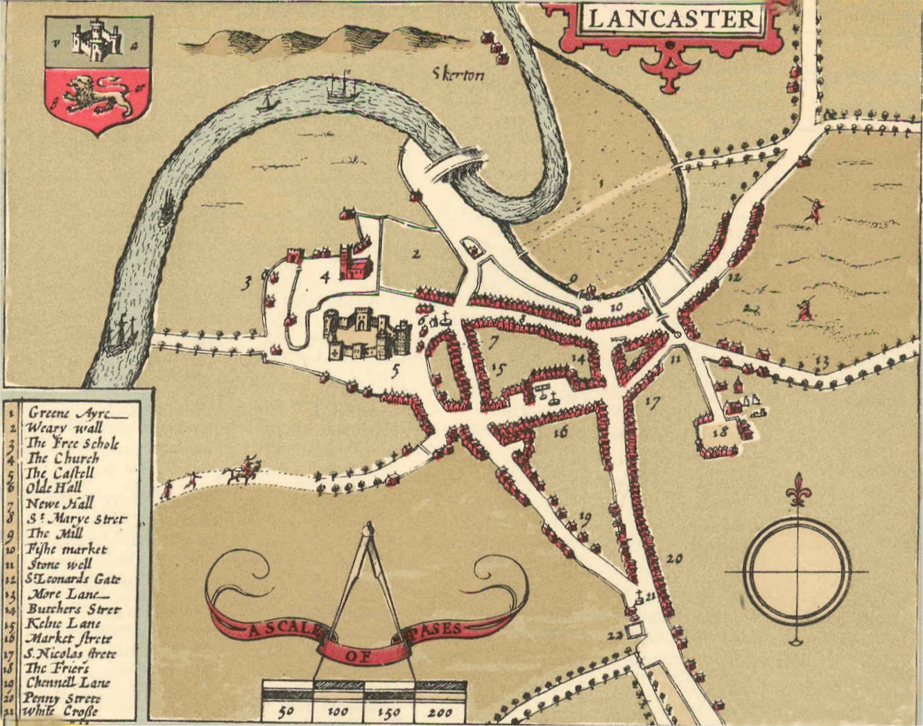
The first map of Lancaster was drawn in 1607 by John Speed.

He used a scale of 50 paces to the inch – 50 paces equating roughly, but not consistently, to about 250 feet.

Two interesting items are The ‘Pinfolde’ an area for penning animals and The Weary Wall which was part of the Roman camp on Castle Hill.

Lancaster Civic Vision has published over one hundred guides, walks and leaflets detailing the outstanding history, heritage and natural beauty of the Lancaster and Morecambe District, all of which are listed and can be read, downloaded and printed – free of charge – from our web page at Guides, Leaflets and Walks to the Lancaster and Morecambe District.

To complement these guides and walks we have also produced a range of Podcasts which explore more details about them and which can be listened to by visiting our page Podcasts, or through Spotify, Apple Podcasts, Google podcasts and Amazon Music Podcasts.

The Earliest Map of Lancaster

Lancaster Civic Vision Guide 65

Lancaster is an old-established town – back to Roman times – but the first map that shows its layout in any detail did not appear until 1607 when John Speed surveyed the town. Here is his map.

Figure 1: John Speed’s plan of Lancaster surveyed in 1607.
Source: http://library.lancs.ac.uk/maps/speed1610.jpg

John Speed’s project was to produce an atlas of each county, to be sold to the well-off.  The map of Lancashire had an inset showing the streets and main buildings of Lancaster, the county town. It is one of 73 town plans in the atlas, which was first published in 1611/12. The full reference of the atlas is given at the end of this leaflet.  An online version of the Lancaster town plan is available on the website of Lancaster University (see above).

This is the key to the numbers (1 to 22) on the main map.
It shows the names of the streets and main buildings

Speed had to get the permission from the Privy Council to carry out his surveys and he completed the Lancaster survey on 17 August 1607. He achieved a lot in one day but inevitably the map is rather sketchy. It was printed in black and white and then hand-coloured before sale. The scale is 50 paces (250 feet) to the inch but is not consistent, particularly in the outskirts of the town.

The ‘Pinfolde’ was an area for penning animals. The Weary Wall was part of the Roman camp on Castle Hill.

Overall, the town itself is fairly accurately portrayed, though the line of the River Lune is odd. The ordinary buildings of the town look formulaic rather than architecturally accurate. The key streets in the town centre are broadly aligned as we see them today.

There is St Marye Strete (now Church Street) running west-to-east down from the Castle and St Mary’s (The Priory) Church. To the south of this and roughly parallel is Market Strete and the Square.

The road from the south splits at the (literal) White Cross (noted on the map) as it does today, with Penny Strete and Butchers Strete (now Cheapside) running northwards and Chennell Lane (now King Street) going to the north-west. The map indicates a ‘Kelne Lane’ where China Street is now; and leading to the east are St Leonards Gate and More Lane (now Moor Lane).

The map also shows some major buildings. There is the Castell/Castle, as it was before the Civil War changed it. ‘The Church’ (St Mary’s Church) is shown with its tower – the medieval one not the current one which is Georgian. Towards the top of the map is the medieval bridge over the River Lune, which was finally demolished in 1846. Also shown on the map but no longer with us are the ‘Olde Hall’ and ‘Newe Hall’ and ‘The Friers’ (roughly where Dalton Square is today).

It is a fascinating map to study. If you would like to know more about this map you can consult these sources:

Webster D N (2020) John Speed’s Town Plan of Lancaster in 1607. Contrebis 38,

   23–8.  Available at https://lahs.archaeologyuk.org/contrebis38.htm

White A (2003) Lancaster: a History. Chichester: Phillmore. Chapter 4     

Here is the full reference to Speed’s atlas.

Speed J 1611/12 The theatre of the empire of Great Britaine: presenting an exact geography of the kingdomes of England, Scotland, Ireland, and iles adioyning: with shires, hundreds, cities and shire-townes, within ye kingdome of England, divided and described by John Speed. London: Sudbury & Humble

Text – Gordon Clark.

Published by Lancaster Civic Vision (©2021).  www.lancastercivicsociety.uk 

Lancaster Civic Vision is the trading name of Lancaster Civic Society, registered charity no. 258434

Weekend Walk 2 – New Architecture in the Lancaster, Morecambe and the District.

The Design Awards scheme was initiated in 1986 by Lancaster Civic Society, the scheme has been run in cooperation with Lancaster District Chamber of Commerce, Lancaster City Council and Lancaster University.

Lancaster Civic Vision, in conjunction with the Planning Department of Lancaster City Council, are discussing ways that this competition can return in 2024 to highlight and promote good building designs within our area.

Lancaster Civic Vision has published over one hundred guides, walks and leaflets detailing the outstanding history, heritage and natural beauty of the Lancaster and Morecambe District, all of which are listed and can be read, downloaded and printed – free of charge – from our web page at Guides, Leaflets and Walks to the Lancaster and Morecambe District.

To complement these guides and walks we have also produced a range of Podcasts which explore more details about them and which can be listened to by visiting our page Podcasts, or through Spotify, Apple Podcasts, Google podcasts and Amazon Music Podcasts.

New Architecture in Lancaster, Morecambe and the District

Lancaster Civic Vision Guide 31

Lancaster District is renowned for its wealth of architectural gems, from the medieval Castle to the Georgian heritage of St George’s Quay and Castle Park, and some fine Victorian and Edwardian buildings such as the Town Hall and the Ashton Memorial.

Fortunately the steady expansion of the district in the last 30 years has produced more, good new buildings and notable refurbishments, and it is these that are celebrated in the Design Awards scheme. Initiated in 1986 by Lancaster Civic Society, the scheme has been run in cooperation with Lancaster District Chamber of Commerce, Lancaster City Council and Lancaster University.

Running periodically, the scheme highlights the new buildings and the refurbishments that are judged to have enhanced the area. In this leaflet we have selected just a few from more than a hundred that have received an award or commendation under the scheme. This personal selection, from among the winners since 2000, shows how modern architecture has benefited a wide range of types of building across the district.

The Midland Hotel, Marine Road West, Morecambe, LA4 4BU. Opened in 1933, and refurbished in 2008, the landward (above) and seaward (below) frontages are shown. See Guide 13 in this series for further details about this Art Deco hotel and its surroundings.

RNLI Lifeboat Station, Marine Road Central, Morecambe LA4 5BY.
Home to the Bay’s rescue hovercraft.
Millennium Bridge, River Lune, Lancaster. A new cycle path and footpath.
See Guide 22 in this series for more details about the Lune’s bridges.
Roundhouse, Robert Street, Quarry Road, Lancaster LA1 1AG
Charles Carter Building, Lancaster University LA1 4YW
Lancaster Cohousing, Forge Bank, Halton LA2 6FD.  An innovative development because of the very high insulation of the houses and for the communal facilities on offer to the residents.
See Guide 96 for more about Halton
Burrow Farm, south Lancaster LA2 0AP – A sensitive enlargement of a farmhouse
Shenstone, Over Kellet LA6 1DL – A refurbishment and extension
Arteria, Brock Street, Lancaster LA1 1UR – A shopfront updated in traditional style
Ripley St Thomas C of E Academy, Sixth Form Centre, Ashton Road, Lancaster LA1 4RS

Some further reading

Discovering Historic Lancaster: a visitor’s guide. (2012) Lancaster: Lancaster City Council.

Text  and photographs – Gordon Clark.

Header photograph – RNLI Lifeboat Station Morecambe at Sunset – Ian Greene                   

Published by Lancaster Civic Vision (© 2014; revised 2022).

Lancaster Civic Vision is the trading name of Lancaster Civic Society, registered charity no. 258434

Weekend Walk 1 – Arnside and Silverdale

Arnside and Silverdale is an Area of Outstanding Natural Beauty (AONB) and is only a few miles north of Lancaster and Morecambe, easily accessible by road and rail with stations at both.

And there is everything for everyone. Nature reserves – including RSPB’s Leighton Moss – woodland walks, coastal walks, sandy beaches, hills to climb with great viewpoints across to the Lakeland hills, and historic buildings to visit.

And of course there are cafes, restaurants, ice cream shops, souvenir shops, a fish and chip shop, and a few pubs just to make sure that you can replenish some of that energy that you have expended.

Weekend Walk 2 looks at some of the New Architecture in the Lancaster and Morecambe District whilst our Bonus item will be the Earliest Map of Lancaster issued by John Speed in 1607

Lancaster Civic Vision has published over one hundred guides, walks and leaflets detailing the outstanding history, heritage and natural beauty of the Lancaster and Morecambe District, all of which are listed and can be read, downloaded and printed – free of charge – from our web page at Guides, Leaflets and Walks to the Lancaster and Morecambe District.

To complement these guides and walks we have also produced a range of Podcasts which explore more details about them and which can be listened to by visiting our page Podcasts, or through Spotify, Apple Podcasts, Google podcasts and Amazon Music Podcasts.

Arnside and Silverdale

Lancaster Civic Vision Guide 42

Arnside (in southern Cumbria) and Silverdale (in the Lancaster district of northern Lancashire) is a quiet corner of the north-west, often overlooked by visitors focusing on the Lake District and Yorkshire Dales. Designated an Area of Outstanding Natural Beauty (AONB) in 1972, the area is mix of low hills, mosslands, woods, fields and small villages.

To the west is Morecambe Bay with its saltmarshes, mudflats and river channels, especially that of the River Kent. There is a big tidal range here and a bore on the Kent’s channel. The eastern boundary of the AONB is the A6 road.

From its offices and information centre (open weekdays) in the Old Station Building at Arnside station the AONB’s staff of just four ensures the protection of the area from inappropriate development and encourages the public’s enjoyment of the natural and built environments.

The map later in this guide shows the dense network of well-signposted footpaths that allow walkers to explore the area. The limestone rocks provide a distinctive habitat for plants not often found elsewhere and the insects, butterflies and moths they host.  In other places there are more acidic soils that extend further the botanical diversity of this area.  Walkers may also see some of the deer that roam the low hills.

There is a rich bird life here. The RSPB’s reserve at Leighton Moss is very well known for its lakes and reedbeds surrounded by deciduous woodlands and fields.  However, all the area’s woodland walks will display a good range of birdlife.

The western shore onto Morecambe Bay, at for example Jenny Brown’s Point, allows the bird watcher to get close to the shore birds of Morecambe Bay, particularly towards high tide and during the winter.

The maintenance of the built environment is also important, not only in the villages of Arnside, Silverdale, Beetham, Warton, Yealand Redmayne and Yealand Conyers but also in the farmhouses and cottages across the area. The stone walls need repairing and there is an active programme of volunteers who help out.

Evidence of the old tradition of coppicing trees can be seen widely. The AONB is actively running projects to keep rural skills alive, to encourage visitors and to improve both the natural environment and the historic landscapes.

By car the area is best accessed via the A6.   By train the stations at Arnside, Silverdale and Carnforth are good points to start your walk or cycling.

The AONB’s website is at: https://www.arnsidesilverdaleaonb.org.uk/

Text – Gordon Clark. Photographs and map courtesy of the Arnside & Silverdale AONB.

Published by Lancaster Civic Society (©2015; revised 2022)

Lancaster Civic Vision is the trading name of Lancaster Civic Society, registered charity no. 258434

Where Are We Wednesday?

A common sight in any town or city – demolition.

This particular set of works in Lancaster were between 1938 and 1939 and changed the way the area looked completely.

Arguably it was to be a brighter future for Lancaster – other might not be so charitable? Time will surely tell?

But where are we?

Demolition work commences
Buildings are removed

The rerouting of old Bridge Lane was a major construction changing the way traffic flowed in Lancaster forever.

The original route of Bridge Lane

A view from the same spot today:

Do you have any before and now photos of the Lancaster and Morecambe area that can feature in our ‘Where Are We Wednesday’?

We would be delighted to receive them together with the story behind them:

Contact – david.morgan@lancastercivicsociety.uk.

Photos and information for the ‘Rerouting of Old Bridge Lane’ thanks to Andrew Reilly, Lancaster past and Present.

Homes From Home – Morecambe Visitors by Peter Wade

Morecambeology 336

The Visitor, Morecambe’s weekly newspaper, proudly declares its existence since 1874. However, as a supplement to the Lancaster Guardian, The Morecambe Visitor is rather older.

Its name comes from what we find on its front page – not the headlines of a lead article but a list of visitors, a kind of who’s who in town.

Thus on 24th September 1869 a list reveals who was staying at the town’s hotels and guest houses. The hotels are the North Western (one day to become the Midland Hotel), the Leeds, Pier, Victoria and Royal Hotels.

An engraving of the North Western Hotel (1847-48) designed by Paley and Austin and renamed The Midland Hotel 1871

The guest or boarding houses are listed street by street.

Pedder Street – Mrs Beaumont’s, Mrs Johnson’s, Mrs Dickinson’s, Mrs Lord’s, Mrs Hothersall’s, Mr Carleton’s, Mrs Siddle’s, Mrs Wilkinson’s, Mrs Haslam’s, Mrs W Taylor’s, Misses Backhouse’s and Mrs Brough’s.

New Street – Miss Newton’s, Miss E Thompson’s, Mr G Bingham’s, and Mrs Carr’s.

Victoria Street – Mrs Andrews’, Mrs Constantine’s and Mr J Turner’s Fair View House.

Northumberland Street – Miss Roe’s, Mrs W Taylor’s and Miss Rutherford’s.

West View Terrace – Miss Fletcher’s, Mrs Perkin’s and Mrs Jackman’s.

Along the seafront Crescent – Mr R Birkett’s, Mrs Fielden’s, Miss Watson’s, Miss Clark’s and Miss Pedder’s.

Neighbouring Queen’s Terrace – Miss T Edmondson’s, Mrs Young’s, Mrs Hatton’s, Mrs Lewis, Mrs Hosking’s, Mrs Woodhouse’s, Mrs T Brown’s, Mrs Greaves’s, Mrs Taylor’s and Mrs Lawson’s at Marine Place.

Clark Street – Miss William’s, Mrs Hansome’s, Mrs Newland’s and Mrs Hall on Cheapside.

Finally, on Townley Terrace – Mrs McGowan’s and Miss Blezard’s at Victoria House.

The great majority of visitors were from Yorkshire and especially Bradford. A few exceptions were ones from London, Manchester, Nottingham, Liverpool, Penrith, Kendal, Milnthorpe, Accrington, Coventry, Settle, Appleby, Kirkby Stephen and Bentham.

Bank Holiday Weekend Walk – Bonus 2 – Map of Lancaster in 1778

By 1778, the town had grown considerably and the town centre is recognisably as it is today.

Lancaster Civic Vision has published over one hundred guides, walks and leaflets detailing the outstanding history, heritage and natural beauty of the Lancaster and Morecambe District, all of which are listed and can be read, downloaded and printed – free of charge – from our web page at Guides, Leaflets and Walks to the Lancaster and Morecambe District.

To complement these guides and walks we have also produced a range of Podcasts which explore more details about them and which can be listened to by visiting our page Podcasts, or through Spotify, Apple Podcasts, Google podcasts and Amazon Music Podcasts.

Map of Lancaster in 1778

Lancaster Civic Vision Guide 66

In Guide 65 in this series we showed Lancaster as it was portrayed in John Speed’s map of 1607 – basically a very small medieval town. By the time of Stephen Mackreth’s map published in 1778, the town had grown considerably and the town centre is recognisably as it is today.  His map is highly detailed, the work of a professional surveyor and showing the outline of individual buildings as well as the streets. It is a large map – 60cm by 72cm.

A number of features stand out. There are the two images in the top-left-hand and top-right-hand corners showing the Castle and St Mary’s Church (The Priory). Unusually, south is at the top of the map. It has a decorative border to make it resemble a framed picture on display in your house. It is an artwork rather than a map to be used for navigation. It was a status symbol for the well off, costing 5 shillings (about £39 in today’s money) or you could buy seven for the price of six. The cartouche in the bottom-right-hand corner is interesting. It indicates the clientele who could afford the map.

The cartouche of Mackreth’s map.
Note the ships and warehouses on the then recently developed St George’s Quay.

So who was the cartographer, Stephen Mackreth?

We know little of his life and this was his only map. At first sight he is an unlikely cartographer.

Orphaned at four years of age, he was probably brought up by George Grey who was one of his father’s executors and a bookseller, as Stephen’s father had been.

Stephen was apprenticed at 14 to a joiner and cabinet maker. By the time he was 17 he was listed as a painter. Few cartographic skills there.

However, George Grey was also a land surveyor – a useful skill if you want to produce a town map. The map is certainly the result of very accurate surveying.

Grey’s son, Bryan, is probably the draughtsman for the map. The copper-plate engraving was advertised as being done in London.

The printing could have been done by Mackreth because by the age of 36 in 1778 he is noted as being a printer too. 

George Grey moved in the right circles among Lancaster’s elite to drum up the subscriptions that would be needed to ensure that the map was a financially sound venture.

Stephen Mackreth died in 1793 aged 51.

The Castle Hill area
The town centre

The map is well worth close study, in terms of what has survived and what has not – the St Nicholas Street area and the Shambles, for example. What other changes can you spot?

Text – Gordon Clark. 

Published by Lancaster Civic Vision (©2021, revised 2022).  ww.lancastercivicsociety.uk

Lancaster Civic Vision is the trading name of Lancaster Civic Society, registered charity no. 258434

Bank Holiday Weekend Walk – Bonus 1 – Eric Morecambe Statue, Morecambe

Eric is in his famous ‘Give me Sunshine’ pose. He faces the town and round his neck are binoculars to show his love of bird watching for which Morecambe Bay behind him is famous. An endearing flock of chubby bronze gulls guards the statue.

It must be one of the most photographed statues anywhere in the UK with everyone trying to adopt a similar pose – often with quite hilarious results!

Lancaster Civic Vision has published over one hundred guides, walks and leaflets detailing the outstanding history, heritage and natural beauty of the Lancaster and Morecambe District, all of which are listed and can be read, downloaded and printed – free of charge – from our web page at Guides, Leaflets and Walks to the Lancaster and Morecambe District.

To complement these guides and walks we have also produced a range of Podcasts which explore more details about them and which can be listened to by visiting our page Podcasts, or through Spotify, Apple Podcasts, Google podcasts and Amazon Music Podcasts.

Eric Morecambe Statue, Morecambe

Lancaster Civic Vision Guide 102

Eric Morecambe is undoubtedly the best known of Morecambe’s actors and comedians. Born John Eric Bartholomew in 1926, he lived with his parents in Buxton Street in Morecambe. He became one of Britain’s top entertainers along with his stage partner Ernie Wise.  Together they worked with increasing success from the early 1940s to the 1980s in music halls, theatres, radio, film and predominantly BBC and ITV television.  At their peak in the late 1970s they attracted record-breaking television audiences. Eric died in 1984.

In 1999 a slightly larger-than-life bronze statue of Eric was unveiled by H.M. The Queen on Morecambe Promenade. Its cost (£40,000) was raised by public subscription.  The sculptor was Graham Ibbeson. It shows Eric in his famous ‘Give me Sunshine’ pose. He faces the town and round his neck are binoculars to show his love of bird watching for which Morecambe Bay behind him is famous. An endearing flock of chubby bronze gulls guards the statue.

Eric Morecambe Statue surrounded by flowers (Source: Ian Greene)
View of Morecambe Bay behind Eric Morecambe Statue (Source: Gordon Clark)
(Source: Gordon Clark)

Leading up to the statue are steps designed by Jonathan Speirs, which are lit up at night. In front of the steps is an open area featuring the names of some of the famous stars and scriptwriters who worked with them.

(Source: Gordon Clark)

There are also many of Eric’s catchphrases. “Tea, Ern?” “Can’t see the join.”  “What do you think of the show so far?” “Rubbish” and “Ruggish.”  

(Source: Gordon Clark)
Eric Morecambe Statue, steps and stars (Source: Ian Greene)
(Source: Gordon Clark)

Text – Gordon Clark. Photographs: Gordon Clark and Ian Greene

Published by Lancaster Civic Vision (©2022)   www.lancastercivicsociety.uk

Lancaster Civic Vision is the trading name of Lancaster Civic Society, registered charity no. 258434